
Plot-level deforestation evidence for the EUDR
Send your suppliers’ plots in whatever shape they arrive. We fix the geolocation to the TRACES GeoJSON rules, screen every plot for forest loss after 31 December 2020 with open EU satellite and forest data, and hand you a bilingual evidence report – reviewed by a licensed surveying engineer.
- TRACES-ready GeoJSON: WGS84, 6 decimals, clean polygons
- Sentinel-2, JRC GFC2020 and Hansen loss for every plot
- LOW / REVIEW / HIGH flags, REVIEW and HIGH checked by hand
Screening service – not a certification and not legal advice. Due diligence and the due diligence statement (DDS) remain the operator’s responsibility.
Key dates
Status checked on 16 October 2026. The EUDR has been amended several times; we re-check the dates every quarter. Hazelnuts are not an EUDR commodity, and leather was taken out of scope in 2026. Deadlines 2026/2027 →
The problem: your due diligence statement needs every plot
From 30 December 2026, coffee, cocoa, wood, rubber, soya, palm oil and cattle products may only be placed on the EU market with a due diligence statement that contains the geolocation of every plot of land where they were produced.
You must also be able to show that no deforestation took place on those plots after 31 December 2020 – for every shipment, kept on file for five years.
In practice supplier data arrives as WhatsApp pins, sketches, Excel lists with swapped coordinates and KML files with open polygons. The EU Information System (TRACES) rejects such files – and nobody in your team has time to fix 400 plots by hand.
Typical data problems we fix
LAT_LON_SWAPLatitude and longitude swapped or in DMS formatSELF_INTERSECTOpen or self-intersecting polygons, holesPOINT_OVER_4HAPoints used for plots larger than 4 haMISSING_AREAMissing area, wrong country code, duplicate plotsLOW_PRECISIONCoordinates with 2 decimals (±1 km)
From messy pins to a clean dossier in four steps
You keep full control: you submit the due diligence statement with your own account. We never ask for your TRACES login.
Send plots
WhatsApp pins, KML/KMZ, GeoJSON, GPX, CSV or Excel – as they come from your suppliers.
Clean & validate
Geometry repaired to the TRACES rules. We only ask you for what is genuinely missing.
Screen every plot
Sentinel-2 2020 vs. today, JRC forest 2020, Hansen loss. REVIEW and HIGH reviewed by the engineer.
Receive the dossier
GeoJSON, EN/DE PDF report, CSV and audit log – in 48 hours for up to 50 plots.
48 hours = two working days after complete data, for batches of up to 50 plots. Larger batches: delivery time agreed in the quote.
What you receive
- GEOJTRACES-ready GeoJSONWGS84, 6 decimals, closed polygons without holes or crossing lines, points only for plots up to 4 ha, ProducerCountry checked against the location.
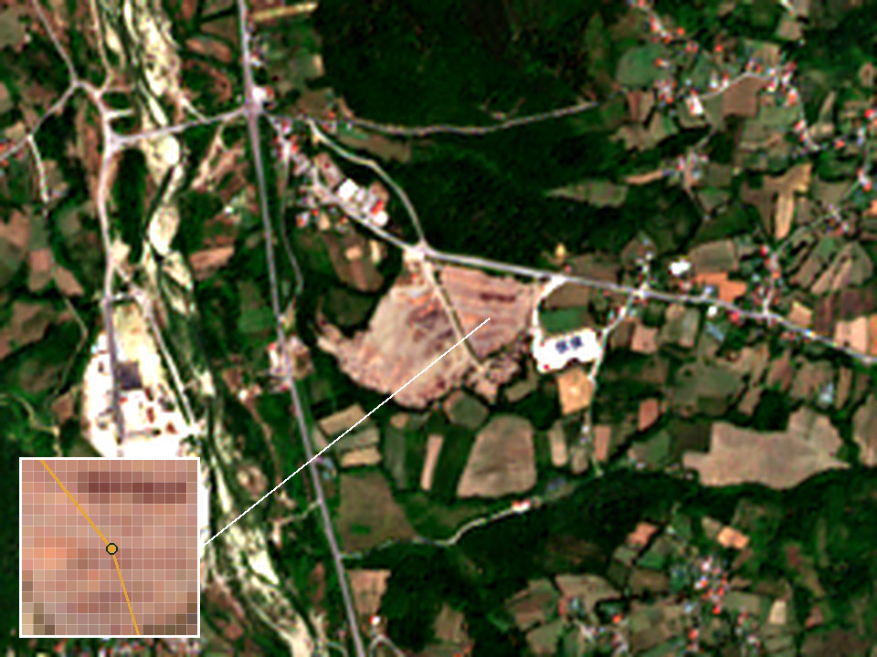
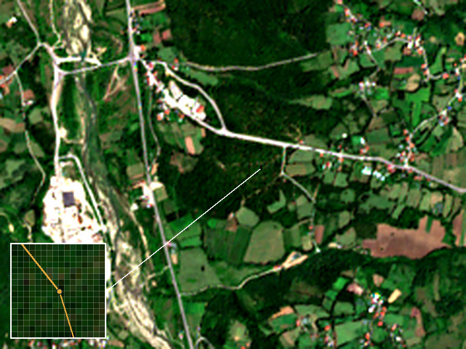
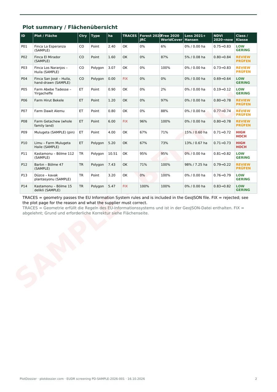
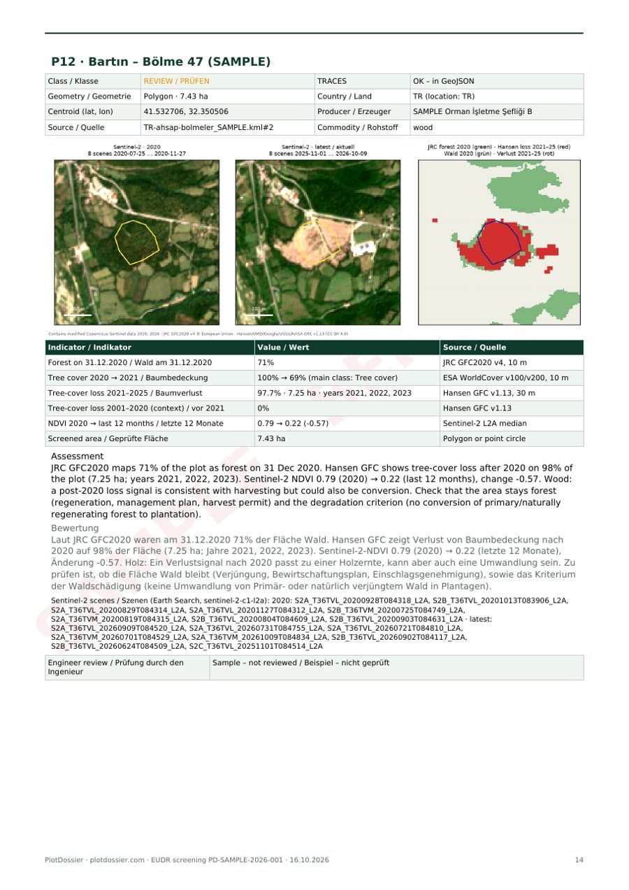
- PDFPDF evidence report (EN/DE)overview map, per-plot table, Sentinel-2 images from 2020 and the last 12 months, forest maps, risk class (LOW / REVIEW / HIGH), sources and limitations.
- CSVCSV summaryfor your ERP or Excel, one line per plot.
- FIXList of rejected plotswith the exact correction your supplier has to make.
- LOGAudit logwith SHA-256 checksums, satellite scene IDs and data versions – for your 5-year record keeping.
LOW REVIEW HIGH
// PD-SAMPLE · P12
{ "type": "Feature",
  "properties": {
    "ProducerCountry": "TR",
    "ProductionPlace": "Bartın – Bölme 47",
    "Area": 7.43 },
  "geometry": {
    "type": "Polygon",
    "coordinates": [[
      [32.352223, 41.533078],
      [32.351371, 41.533877],
      … 7 more vertices, closed ring
    ]] } }
A report your auditor can follow
Every batch ends in one PDF in English and German: overview map, a table with geometry status and risk class for every plot, and one page per plot with Sentinel-2 images, forest maps, findings and the data versions used.
Simple, per-plot pricing
Start with three plots for free. After that you pay per plot or per supplier – no subscription required.
Plot screening
- Your data is already clean (GeoJSON/KML/CSV)
- Validation + screening + risk class
- CSV + GeoJSON + PDF report
- €2 per plot from the 101st plot
Evidence pack
- Up to 50 plots
- TRACES GeoJSON + EN/DE PDF report
- Engineer review of REVIEW/HIGH plots
- Audit log (SHA-256)
All packages & payment → All prices in EUR, net. For businesses in the EU, VAT is reverse-charged (see payment).
Who it is for
EU importers & traders
Coffee, cocoa, wood, rubber or soya buyers who need clean geolocation data from many small suppliers before submitting a DDS.
Wood & furniture exporters
Turkish wood, furniture, paper and pallet exporters: Türkiye is a low-risk country, but geolocation of the harvest area is still required.
Producers & cooperatives
Coffee and cocoa cooperatives in Ethiopia, Colombia, Uganda and elsewhere whose EU buyers ask for plot polygons.
Open data, documented sources
We use open, documented datasets only. No Google, Bing, Esri or Mapbox imagery.
JRC Global Forest Cover 2020 (GFC2020) v4
10 m forest / non-forest map for 31 Dec 2020, by the European Commission's Joint Research Centre. © European Union.
Hansen Global Forest Change v1.13
30 m annual tree-cover loss 2001–2025. Hansen/UMD/Google/USGS/NASA, CC BY 4.0.
ESA WorldCover 2020 & 2021
10 m land cover, used to cross-check tree cover. © ESA WorldCover project, CC BY 4.0.
Copernicus Sentinel-2 L2A
10 m imagery, cloud-masked median of 2020 and of the last 12 months. Contains modified Copernicus Sentinel data.
What this service is not
- Not a certificate or approval. The EUDR does not provide for certificates – no service provider can issue an “EUDR approval” for a product.
- Covers only the deforestation-free criterion. Legality under the laws of the country of production (land rights, labour, tax, environment) needs documents from your supply chain.
- Locations are the ones you or your suppliers declare. We check format and plausibility, but this is not a cadastral survey.
- Satellite data has limits: 10–30 m pixels, clouds, shade-grown coffee and cocoa. That is why REVIEW and HIGH plots are checked by a person.
EUDR guides – checked against official sources
Practical answers for importers and their suppliers. Every statement links to EUR-Lex, the European Commission or the TRACES documentation.
How to prepare EUDR geolocation data (GeoJSON) for TRACES
Step-by-step: how to build an EUDR geolocation file the EU Information System (TRACES) accepts – WGS84, 6 decimals, closed polygons, ProducerCountry, Area, the 25 MB limit and the 12 most common rejection reasons.
Read the guide →Deadlines 2026/2027EUDR deadlines 2026/2027 explained for SMEs
EUDR application dates after Regulation (EU) 2025/2650: 30 Dec 2026 for large and medium operators, 30 Jun 2027 for micro and small operators – with the EUTR wood exception, the new simplified declaration and the 2026 product-scope changes.
Read the guide →Point or polygon (4 ha)Point or polygon? EUDR plots under and over 4 hectares
When is a single GPS point enough for EUDR geolocation and when do you need a polygon? The 4-hectare rule, the cattle exception, the default Area of 4 ha in TRACES, precision of 6 decimals and practical tips.
Read the guide →
The engineer behind your plot data
Ömer Kaşıkcı is a surveying engineer and a licensed real-estate valuation expert in Türkiye. He has been in the field since 2001, starting with surveying field work as an intern. He graduated in Geodesy and Photogrammetry Engineering from Yıldız Technical University in Istanbul in 2004 and has been a registered member of the Chamber of Surveying and Cadastre Engineers (HKMO) since 2005.
He is one of the co-founding partners of a corporate valuation firm licensed by Türkiye’s Capital Markets Board (SPK) and Banking Regulation and Supervision Agency (BDDK) that works in around 60 provinces. For about 15 years he acted as a court-appointed expert witness at the İzmir courthouse in expropriation, zoning, ownership and valuation cases. Abroad, he led the valuation of around 1,000 properties in Almaty, Kazakhstan, for a Kazakh-partnered bank.
PlotDossier applies that routine – parcels, coordinates, documented evidence – to EUDR plot data. The licences below are professional credentials in Türkiye, not an EUDR certification; the EUDR does not provide for one.
Every plot the screening flags as REVIEW or HIGH, I look at myself before the report leaves my desk.
- Surveying engineerHKMO reg. no. 8798, İzmir · member since 27.07.2005
- Valuation expertSPK licence no. 401356 · issued 26.04.2010 (TSPAKB register)
- EducationYıldız Technical University, Geodesy & Photogrammetry Engineering, 2004
- Court expertAbout 15 years at the İzmir courthouse (expropriation, zoning, ownership, valuation)
Details in the imprint. Languages: English, German, Turkish. Based in Çeşme/İzmir.
Try PlotDossier with three plots
Send three plots from one supplier. Within two working days you receive the geometry check, the risk flags and a short PDF report – free and without obligation.